


Home | About | Historical Marker Program
Location: near Cathedral Mountain trailhead in Gloss Mountain State Park
Coordinates: 36.363008, -98.579081
Material: Granite
Sponsor(s): Gloss Mountain Conservancy, Inc.
Topics: Environment/Cultural Ecology; Territorial Period, 1861–1907
The name “Glass Mountains” appeared on a map issued by the General Land Office in February 1873. Two years later, the same office issued another map that labeled them “Gloss Mountains,” thus precipitating a conflict that continues to this day. The 1875 map resulted from a survey led by an engineer named T.H. Barrett. Historiographer James Cloud is of the opinion that a draftsman copied this map and misread the “A” for an “O”. A persistent legend exists that a member of that first exploring party was British or Bostonian. This member awakened early one morning in the survey camp on the knoll located east of this point and saw the sun on the glistening clear crystals of selenite. In his long Eastern dialect he exclaimed. “Why, they look just like glaws.” The party’s cartographer simply recorded what he thought he had heard, indeed a passing error.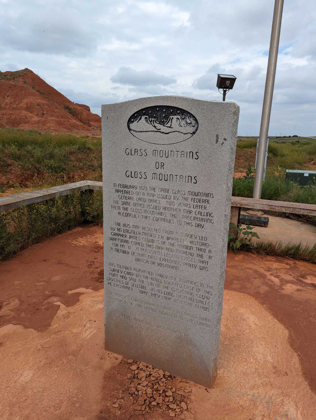
(Page 1 of 1)
Historical Marker Program
Search Results
Your search returned 1 result.
Glass Mountains or Gloss Mountains
Major CountyLocation: near Cathedral Mountain trailhead in Gloss Mountain State Park
Coordinates: 36.363008, -98.579081
Material: Granite
Sponsor(s): Gloss Mountain Conservancy, Inc.
Topics: Environment/Cultural Ecology; Territorial Period, 1861–1907
The name “Glass Mountains” appeared on a map issued by the General Land Office in February 1873. Two years later, the same office issued another map that labeled them “Gloss Mountains,” thus precipitating a conflict that continues to this day. The 1875 map resulted from a survey led by an engineer named T.H. Barrett. Historiographer James Cloud is of the opinion that a draftsman copied this map and misread the “A” for an “O”. A persistent legend exists that a member of that first exploring party was British or Bostonian. This member awakened early one morning in the survey camp on the knoll located east of this point and saw the sun on the glistening clear crystals of selenite. In his long Eastern dialect he exclaimed. “Why, they look just like glaws.” The party’s cartographer simply recorded what he thought he had heard, indeed a passing error.
(Page 1 of 1)
Marker Search
Browse by County
Adair County
Alfalfa County
Atoka County
Beaver County
Beckham County
Blaine County
Bryan County
Caddo County
Canadian County
Carter County
Cherokee County
Choctaw County
Cimarron County
Cleveland County
Comanche County
Cotton County
Craig County
Creek County
Custer County
Delaware County
Dewey County
Ellis County
Garfield County
Garvin County
Grady County
Grant County
Greer County
Harmon County
Harper County
Haskell County
Hughes County
Jackson County
Jefferson County
Johnston County
Kay County
Kingfisher County
Kiowa County
Latimer County
Le Flore County
Lincoln County
Logan County
Love County
Major County
Marshall County
Mayes County
McClain County
McCurtain County
McIntosh County
Murray County
Muskogee County
Noble County
Okfuskee County
Oklahoma County
Okmulgee County
Osage County
Ottawa County
Pawnee County
Payne County
Pittsburg County
Pontotoc County
Pottawatomie County
Pushmataha County
Roger Mills County
Rogers County
Seminole County
Sequoyah County
Stephens County
Texas County
Tillman County
Tulsa County
Wagoner County
Washington County
Washita County
Woods County
Woodward County
To find out more about the Oklahoma Historical Society Historical Marker Program or how to submit an application, please visit the Historical Marker Program page.
Missing or Damaged Markers
Please use our online form to report missing or damaged historical markers.
Report Missing or Damaged Markers
Contact Us
If you have questions, please contact:
Matthew Pearce
Oklahoma Historical Society
800 Nazih Zuhdi Drive
Oklahoma City, OK 73105
405-522-8659
matthew.pearce@history.ok.gov